Wednesday, December 21, 2011

Happy Holidays ~ the last blog for 2011!


Hard to believe its nearly the end of the year already, and what a year its been!  From the hard times following the devastating quakes in Canterbury, to the highs of GeoNet turning 10. We are all hoping that 2012 will come with less geological hazard activity, well a little bit is OK - we are on a plate boundary after all!
I hope to blog more adventures with our technicians, and other exciting things that happen at GeoNet including the replacement of our earthquake location system (more info here )

The GeoNet tree - with quake proofing!
As many people begin the wind-down at work, i thought i would remind everyone that GeoNet is 24/7, when you feel any earthquakes over the break, don't worry our team will be onto it!  Each day (including Christmas) we have one seismologist - based at Avalon, and one volcanologist - based at Wairakei on duty, armed with pagers and close to their computers. So fingers crossed for a uneventful (hazard speaking) few weeks, with some nice weather for BBQs and fun at the beach!

Speaking of weather, my friend Philip Duncan runs the WeatherWatch website, and they have the official Christmas Day forecast here, and its looking good - don't forget your sunblock!

So happy holidays and thanks to all the GeoNet fans out there from myself and the team at GeoNet, we look forward to bringing you new and exciting things in 2012!

-  And i hope everyone remembered to quake proof their Christmas trees!

SARA

Tuesday, December 20, 2011

Nelson Rapid Response

With a state of emergency still in place in Nelson following last weeks heavy rain/flooding and landslides GeoNet are currently working with Civil Defence, with our landslide rapid response capability.
Sam working hard

Technicians are in Nelson today installing a continuous-GPS site at Grenville Terrace, on a major landslide where 30 houses have already been evacuated as further land movement is possible. cGPS sites, using satellites, allow scientists to accurately record ground movement

Info on GeoNets landslide rapid response capability here

Our thoughts are with all of the displaced families and those affected by the flooding/landslides especially so close to Christmas!


cGPS - freshly installed

Drill rig

Thursday, December 15, 2011

Foo Fighters rocked Auckland!

You can almost pickout individual songs on the signal!
 
Two seismic stations in the Auckland GeoNet seismic network recorded the ground literally rocking to the Foo Fighters gig at Western Springs on Tuesday night.  The Herne Bay -HBAZ and Eden Park -EPAZ (with IESE-Auckland Uni) stations are 1.5 and 2km from Western Springs respectively and recorded a strong low frequency signal associated with the Foo Fighters gig.

The first vibrations were recorded around 7:30pm, part way through the Tenacious D set, but the biggest shakes started at 8:20pm when the Foo Fighters took the stage, and then it all went quiet at 11pm when the gig ended.
The concert vibrations were recorded as a semi continuous harmonic signal with a peak osculation of 3Hz,  ie the ground was shaking 3 times per second in a nice rhythmic motion.  There are lulls in the signal between the songs and peaks in signal intensity during the songs.

The cause of the shaking is most likely the weight of the 50,000 fans dancing, as 50,000 fans is equal to around 5,000 tonnes of mass moving(or moshing)on the ground for the duration of the concert.  This set up a nice harmonic vibration in the ground which was recorded in our nearby borehole seismometers.

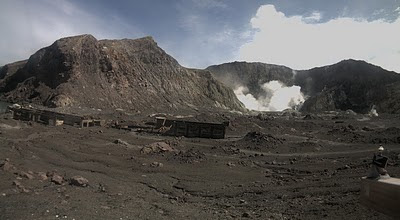
The sound system, probably contributed as well, especially the bass frequencies coupling in to the earth.  The signal is similar to volcanic tremor that is recorded at places like Mt Ruapehu and White Island, however the strong correlation in time with the Foo Fighters concert and the fact it was only recorded on the 2 stations close to Western Springs assured us it was of man-made origin.

Detail of the signal showing the 3Hz vibration
This is not the first time the Auckland instruments have picked up neat sounds, the Rugby World Cup finals were also seen!

Thanks to Craig Miller and the Wairakei GeoNet crew for the info!

Wednesday, November 23, 2011

Out and about - Auckland

I recently traveled up to Auckland to speak at the annual 'Planning for a volcanic crisis' short course - this is a two day course designed for people involved in all aspects of natural hazard management, emergency managers, local council and planners etc.  Auckland is a great place to hold this course as it is built upon a volcanic field made up of over 50 separate volcanoes! 
Volcanoes in NZ


There are three types of volcanoes in New Zealand:
*Cone eg. Ruapehu and Egmont,
*Caldera eg. Taupo,
*Volcanic field eg. Auckland and Northland,

You can find more info on the different types of volcanoes here .  

In Auckland each eruption has occurred at a different location, with a single 'hot spot' of magma about 100km below the city, this means that any new activity will come from a different area - not one of the existing volcanoes. Today most of these volcanoes have been quarried, made into parks or been built on.

The field will probably erupt again as overseas examples show that volcanic fields can last for a very long time (over 1million years) and the Auckland field is only around 250,000yrs old - if it helps volcanic fields typically produce small
infrequent eruptions compared to the other types.    You can get more information, and see how GeoNet monitors the Auckland Volcanic field here


Islington Bay
The last eruption in Auckland was about 600yrs ago at Rangitoto Island, we headed over on a ferry to check it out! We had great weather for the trip as well! 

Rangitoto Island was formed during two eruptions, 600 and 550years ago, it is 260m high and can be seen just North-East of Auckland city.  Thanks to DoC Rangitoto is pest free and also the home to the worlds largest Pohutukawa forest!  

You can see various neat geological features on the island, and even explore lava tunnels. These are formed from paehoehoe lava flows, where the exterior cooled and crusted over creating a tube that allowed the molten lava within to continue flowing, as the lava flow decreased at the end of the eruption, these tunnels were left behind. (if you visit take a torch, sturdy shoes and don't think of wetas!!)


A video of some of the sights below...


Are you prepared?   Get Ready, Get Thru   

Wednesday, November 2, 2011

Out and about - Christchurch Day 2

Hi-viz swarm at Brighton
All of the forum attendees donned their hi-viz vests, and a sea of orange and yellow went out to visit sites of interest to see the physical impacts of the earthquake and the progress with recovery.

One of the sites included the (now old) Brighton sub-station which sunk quite a bit due to the liquefaction -you can see in the photos below - a new substation has now been built.

Note the door!


On a slight lean!


Another interesting site we visited was the Bromley Wastewater
treatment plant (just a tad stinky!) Their main problem to face was the large amount of silt coming into the plant, with not much physical damage caused by the actual ground movement.


The various treatment tanks

This was slightly unnerving!

Luckily they had these!


Tuesday, November 1, 2011

Out and about - Christchurch

Today i am in Christchurch for the annual 'National Lifelines Forum', this is where members from our energy, telecommunications, transportation and water sectors gather and discuss experiences/lessons etc from the past year. Obviously this year there are a lot of discussions on the Canterbury earthquakes and how each sector was damaged and dealt with the various challenges this presented.  GeoNet (including myself) will also be presenting tomorrow.

Going for a walk in the sun at lunchtime,  it was strange to see the beautiful buildings in various pieces, and the skyline full of large cranes, but nice to see the businesses still open - even if they had to move to quirky temporary sites.

One place that i was please to see open was the Canterbury museum, where I popped in to visit a friend, he kindly took me around and showed what little damage the museum sustained, thanks to extensive earthquake-proofing some years ago, i also got a sneak peek at an upcoming exhibit -  Hearts for Christchurch "which showcases an amazing array of more than 4,000 stitch-craft hearts from around the world. The project of an inspirational Napier woman, Evie Harris, who started creating and gathering the hearts after the February earthquake."

I then went to see the new 'container mall' at Cashel street, it is amazing and it was great to see so many people out enjoying the sun and shopping.
Pics below . . .

Cute Kia Kaha 'flower'
Arts Centre


Cashel St  'Container Mall'
Bridge of Remembrance
 

Wednesday, October 26, 2011

Volcano cameras ~ Bugs, aliens and more!

This picture was sent in on the weekend (great spotting, thanks Ross) its a great pic as you can see a black-backed gull flying past (and you can actually see the top of ) Mt Egmont /Taranaki! 

It got me thinking to some other strange things we have seen on the volcano cameras over the years ....


On the left, a spider has a made a home on the Ruapehu cam, and on the right a fly is hanging out with Dino on White Island.

You can also see Dino supporting the All Blacks here


We often get emails in from people curious about black dots (or aliens) showing up on the webcams:

I can assure you these are not aliens!  When the sun is shining directly onto our cameras, they find it a bit bright so the sun is shown as a black dot!

At white Island you can also see the robot-looking camera reflected onto the image.


And here a red 'alien' caused by another camera reflection.

We often see the helicopters landing on White Island and various tour groups (so next time make sure and wave)


To see the current pictures from the volcano cams click here they are updated every 15 minutes.


Friday, October 21, 2011

Out in the field - Taranaki 1.1


The second part of our day was spent out in the field, the TRC have rain gauges at a few of our sites so they travel out there often and have a look at our sites to same sure they are looking ok and help keep our sites tidy (clearing overgrowth, fixing fences and aerials etc) 


First stop was the North Egmont visitors centre to our seismograph site NEZ which was all in order (despite the rain and hail) and after checking the councils rain gauge (very full)  we went to our next site.


DREZ
DREZ  is located on a dairy farm, and once we waited for the cows to meander their way to the milking shed, we found the site. With no cows to eat the grass within the fence, it tends to get quite long and can even block the solar panels, so Andrew took to it with a weed-eater and its all pretty again!


We keep detailed information on all of our sites, including landowner details and precise details on how to get to each site. Since its construction in 2008, the farmer has moved some fence-lines and the site is in a new paddock, so i made notes of the new directions to the site, and this will be updated on our DELTA database - where this information is kept.

DREZ after clearing the grass


German Hill


We then did the same at our German hill cGPS site.

Wednesday, October 19, 2011

Out in the field ~ Taranaki 1.0

This week i traveled up to New Plymouth (to some not-so-fantastic weather)  for a meeting, and also i met up with Andrew a Hydrology Officer from the Taranaki Regional Council (TRC).  Back in the pre-GeoNet days the council looked after a small network of instruments around the area, we have since taken these over, upgraded them and added a few more sites (you can see the network here).  Due to their experience and knowledge of the network, the council have a unique relationship with GeoNet where their staff help maintain our current sites and occasionally help our technicians build new sites - this saves a long travel time as our technicians are based in Taupo and Lower Hutt!
 
Our first stop was the Taranaki Emergency Management Office (TEMO) which is home to one of our volcano cameras (which you can see on our website here), strong-motion instrument NPCS and a repeater-hub where data from other sites goes to TEMO and is then sent on to our data centres (at Wairakei and Lower Hutt).

TEMO
Volcano camera (circled) New Plymouth city in the background

The strong-motion instrument.

Data from other sites coming into the 'repeater hub'


Saturday, October 1, 2011

Volcanoes, a Dinosaur and Rugby?


So its a big weekend rugby wise all around New Zealand - go teams!

As you know GeoNet monitors all of New Zealand's active volcanoes - one of which is home to 'Dino the dinosaur' - normally he just chills out in the crater of White Island, but he has recently decided to show his support to the boys in black!

So we hope everyone has a fantastic weekend, and you can see Dino here (during the day!!)


Tuesday, September 27, 2011

Out in the field - the perils of lightning!

Last week one of our Senior Technicians - Dan, went down to Wednesday Peak and Welcome Bay in Fiordland (here) to replace and upgrade some radio gear that had recently been damaged by lightning. These sites have the important task of transmitting data from the tsunami monitoring site PUYT (Puysegur) back to  HQ.
Wednesday Peak
Helicopter leaving the site


Dan then traveled to the other end of NZ, to North Cape (here) (along with a technician from Maritime NZ), to investigate an outage of the tsunami monitoring site NCPT (North Cape). When they arrived it was clear that the lighthouse next to the site had sustained a direct lightning strike and was effectively destroyed, the lightning had also destroyed all of the equipment for our tsunami gauge. Although lightning protection was installed, it was ineffective against such a large strike. Everything at the site was replaced, with divers traveling within the next week to replace the actual tsunami sensors in the water - as the lightening traveled all the way down (over 250m) to the sensors in the water!.  


North Cape

Lighthouse and GNS Site(right)


Lightning damage inside the cabinet


Although traveling to these remote locations involves long hours and hard work, the technicians do get to see some amazing views of our beautiful country, and occasionally some wildlife... 

 
This whale was spotted in Te Waewae Bay.


Thanks to Daniel for taking the pics and telling me what he got up to (and for putting up with my pestering)

Monday, September 19, 2011

Exploring the website - ShakeNZ

When you go to the GeoNet homepage you will see a map of NZ covered in small squares, this is 'ShakeNZ'.  Each one of the squares gets near real-time shaking (this means in a few minutes, not right away) from our instruments out in the field.   So within a few minutes of an earthquake, you can look at the map and get a rough idea of where it was and the intensity of the shaking.

The key thing here is actually to do with the key!   The pic on the right is the key for the map, which shows intensity, not magnitude!   So when there is an earthquake and you can see an area of coloured squares, they are showing the intensity of shaking not the size.

The numbers correspond to the Modified Mercalli Intensity Scale, this is a really handy way to describe the effects of an earthquake, and is generally better than using the magnitude alone (as a mag 4 quake at 5km depth will produce a higher shaking intensity than a mag 4 at 10km depth)  It goes from MM 1 (barely felt by a few people) to MM 12 (complete devastation).

<---  This is what the map looks like with no activity, small blue/purple squares (blank = no data)


This is the map after a mag 5.5 earthquake, 30km deep near Wellington. -->


Now occasionally when we have technical issues ( the instrument is having a bad day, or a tech is out fixing something)  there will be a 'rogue' square!  Its usually pretty easy to see that its an error and not a large earthquake as there is just one square showing a high intensity, and when there is an actual event multiple squares will be 'lit up' .  
The map on the left shows one station/square showing an orange square, or 7 intensity of shaking, if this was an actual event the squares close by would also show some level of intensity.  There are more examples here.


You can also use an interactive version here  and go from 60min to the present - a cool way at looking at the squares light up following an earthquake.   


Friday, September 2, 2011

Felt Reports: Then & Now


GeoNet collects earthquake data directly from the public via our website where people can answer questions about what they felt during an earthquake. We use this feedback to assist with mapping the distribution of shaking intensity of earthquakes(see here ) and with scenario planning for future earthquakes.

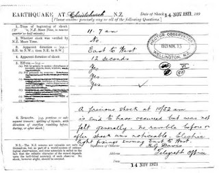
These days its a quick questionarre on our website, however, back in the early 1900s (pre-internet -shock horror) things were slightly different! There was no GeoNet and no network of instruments across New Zealand.

For many years dedicated volunteers completed reports, filling in paper questionnaires and sending them to the observatory in Wellington.  Pre-1930s these, along with newspaper clippings, were used by scientists to calculate where an earthquake was located.  This was difficult in NZ as most people lived by the coast, so not much was known about the effects of earthquakes further inland.
Christchurch 1921

We keep all of these old records here at GeoNet
and they can be quite amusing to read, i have scanned 3 examples of 'felt reports' and one old Press article for you to look at here -->


Christchurch 1921
So next time you feel an earthquake and are (very paitently of course) awaiting the details from GeoNet, think back to the earlier years - they never got to find out how big the earthquakes were! 

Palmerston North 1923


Sunday, August 28, 2011

Out in the field - Canterbury : Day 3


 Day 3 - Lara and i packed up and headed back up to the hills above Akaroa, where we put out one more test site.

And then drove back to Christchurch


With a quick photo-stop at McQueens Valley, home to our popular MQZ.


The last stop was up Richmond Hill at Sumner, it was the first time i had been there since the Sept 4th quake, and wow what a difference.  The roads were definitely 'munted' (a popular post-quake phrase) and it was surreal driving around the coast and seeing the wall of containers, to protect from the rockfalls, and the houses perched precariously on the edge of the cliff.


There were still Port-a-loos on every street, and very damaged houses, on the drive up the hill.  


Our temporary site is right at the top, on a new subdivision , we changed over the batteries and then it was back to Wellington.  The site has amazing views, i wonder if people will still buy there?


From up high, things almost looked 'normal'.


Nb: i didn't make Lara do all of the hard work, i did manage to make it into one photo ; )