Friday, December 21, 2012

The End is Nigh...

And many people are beginning to wind down for the year, and some have finished already.

Although many of us will be out of the office, GeoNet is 24/7 so we will have people monitoring earthquakes, volcanoes and landslides etc throughout the holidays. Social media will also be taken care of as some of us *cough* can't stay off our phones!

So although we have fingers and toes crossed for a geologically/hazardy uneventful holiday break, if anything does decide to play up don't worry, we will be onto it.

All news and Volcano Alert Bulletins etc. will still be posted here

And if you ever have trouble finding any news stories, or data try the search box (see -->)


So HAPPY HOLIDAYS! (And here is a little festive Simons Cat for your Friday amusement)


Wednesday, November 21, 2012

Volcanoes, Eruptions, Oh My!

Well the second half of 2012 has been all about the volcanoes! Tongariro and White Island in August then maybe Ruapehu, but no Tongariro again!

So firstly some important information on what to do during during an ash fall event and lava flows and general information for before/during/after an eruption from CDEM.

Where to find information on our website:

Current status of the volcanoes, drums and cameras here
News and Volcanic Alert Buletins here
More information and history on Tongariro here and our other volcanoes here

What do the alerts mean?


So what does this mean?

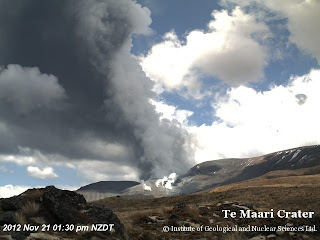
Unfortunately we don't know what will happen in the days to come. As far as eruptions go this was just a small one, only lasting five minutes. And there were no signs that Tongariro was going to erupt again today, volcanoes can be sneaky like that!

We do have lots of seismic sensors on and around the volcanoes and cameras watching the mountains as well as a great team of experts currently looking at all of the data coming in! So we will be closely monitoring the volcanoes and putting out bulletins as more information comes in.

View from Te Maari Crater shortly after the eruption.


Friday, November 2, 2012

Lots of earthquakes - What does this mean?

Another comment we often see is "there have been xx earthquakes today, what does this mean"

We it means that we are living in a really interesting place! New Zealand is located on the boundary of two of the world’s major tectonic plates – the Pacific Plate and the Australian Plate. Below is a video explaining how this plate boundary creates earthquakes in NZ.


Another thing to remember with our new website is that we are showing you all of the earthquakes that we locate, the old website just had the larger/felt events.  And we locate over 20,000 earthquakes a year!

As you can see in the picture below, the earthquakes occur along the plate boundary in both the North and South Islands. The shallow earthquakes (under 40km deep) occur across quite a wide area (pink - red dots) while the deeper quakes (below 40km deep) occur on the sloping surface that shows where the plate boundary dips down at an angle (orange - yellow - blue dots)

All located earthquakes in 2011 (24,000) via QuakeSearch


Another cool thing you can see on our new website is a summary of earthquakes in the New Zealand region  here

You can see that as of this morning, we have had 168 earthquakes of mag 2-3 in the last week.


So lots of earthquakes in one area....

Can mean you are having a swarm = a swarm is a sequences of many earthquakes, usually in a short time period (hours to days). These occur all the time in NZ, with Taupo, Rotorua, Matata and Te Aroha being popular locations! 

They are normal processes and can be related to the long term tectonic stretching of the crust that occurs in the central North Island.


More info:

Stats on earthquakes from 1960

 
Neat Diagram of the plates in NZ

Video of the tectonic evolution of NZ

Historical Earthquakes in NZ

Friday, September 7, 2012

Exploring our new website - Pt 1

Our new website went live this week and we hope you are all enjoying it! I thought I'd do a wee series of posts to help you find your way around!


The first important part are the three main places to get your information:

- Quakes: Every earthquake located in New Zealand! Along with seismic drums and statistics.

- Volcano:  Home to cameras, drums and the current status of the volcanoes.

- Info : Which has all of our latest news, hazard info,  maps of our networks, and our raw data.

You can access these different areas by the black bar which is at the top of each page (see pic above)


Quakes

 - When you go to www.geonet.org.nz this is where you will find yourself here (only the last three felt earthquakes are shown so the page loads quickly!)
- Using the navigation bar (circled in the pic on the right) you can select a region and see all of the recent events there and you can choose to see ALL or FELT earthquakes. This is also where you will find the seismic drums.

Volcano

-Here you can select a volcano and see its current alert level, drums and photos from our volcano cameras

 Info

- News: All of our latest news articles, volcano alert bulletins, and updates
- Data: Where you can access all of our raw data, and find quakes via QuakeSearch
- Networks: View maps of all of our networks across NZ, individual site information and information on the equipment we use
- Geohazards: This is where you will find info on earthquake, volcano, tusnami and landslides

Some tips

See a question mark ? -  hover your mouse over it and get more info

See a link with a information i sign next to it - this link will take you to the Info part of our website

Looking around info - check out the page 'tree' on the left hand side for more pages to look at

Click on Maps for a cool interactive time-map


And finally, we are still tweaking a few things, and more features will be added in the near future!

Monday, September 3, 2012

Changes to our Twitter feeds & Facebook

From Wednesday our new website is officially live, along with Rapid earthquake notifications so our twitter-feeds will change a wee bit:

TWITTER


FACEBOOK 
  • Will be using @geonet so will be posting all the felt events onto the Facebook page


More info on the website changes here:

http://geonet-shakennotstirred.blogspot.co.nz/2012/08/geonetorgnz-change-is-coming.html

http://geonet-shakennotstirred.blogspot.co.nz/2012/08/more-change-earthquake-notifications.html

Tuesday, August 21, 2012

More Change : Earthquake notifications

Continuing on from my last post on the upcoming changes to www.geonet.org.nz, the move from human to automated earthquake location is bringing you faster information but it also means a few things will have to change.

At the moment when an earthquake is located the information is posted onto the website and then sent out to emails / twitter/ facebook etc. and this can take up to 20min.

Now SeisComP3 has an initial quake location out within a few minutes of an event, this then gets revised as more data comes in. So this is where the change comes in!

We will now be able to give you event information a lot quicker than before, but due to the 'history' of the quake and the slight change in size / location when more data comes in, the format will change.

Our GeoNet Rapid feed on Twitter has already been using this format for a while, see the pic on the right.

So you see, you will have to click the link to get all of the quake details and the final location. But you will be able to see, within a few minutes, that there was a event of xx intensity in xx area. (reminder on intensity at the bottom of the page)

From early September you will see these changes on Twitter, Facebook and emails as well as on the website.
Frequent users of GeoNet Rapid and those of you with our android /iPhone apps will be more familiar with this.

We do understand this will take a wee bit of getting used to, but you will be getting information faster than ever before!

Wednesday, August 8, 2012

GeoNet.org.nz - Change is coming!


Back in 2002 this is what the GeoNet website looked like!
(Not very exciting!)

And I'm sure everyone knows what it looks like now!

But with the arrival of our new, faster earthquake location system SeisComP3 We have been busy behind the scenes upgrading GeoNet the website, to make our information easier for you to see.

Some of you would have seen this with our GeoNet rapid beta website

From the September 1st this will no longer be a beta-testing page, it will be the official site of GeoNet earthquake information. With all of NZs earthquakes posted and within a few minutes of their occurrence!  You can easily view by region and 'all' quakes or just 'felt' quakes.

Now something different we have done is made GeoNet into 3 different websites, they are all joined by the black bar you see at the top of the GeoNet rapid page. There is a volcano, earthquake and information site 

So although 3 different sites, they are all linked and will be easily accessible for you all. 

Second we have the Volcano beta site:

Here are a couple of screen-shots  (its online so some of you may have have a look). You can see we have all of the volcanoes in NZ and you can easily see their current status (eg erupting or not!)  
You can then click on a particular volcano and get more information on their status and see pictures and videos from the volcano cameras.


Now the third website is where you will get all of your information, and data. 

So what we do at GeoNet:
* Earthquakes - how we locate them what causes them etc.
* Volcanoes - how we monitor them, historic eruptions etc. 
and not forgetting landslides and tusnami.

You will also have all the information on our networks and equipment we use and access to all of our data we collect that is available for you to use (for free!!)
And we will have pages with information all grouped together on the latest events such as the Canterbury earthquakes and the latest eruption(s) in NZ. We will also have all the latest news, volcano alert bulletins and GeoNet news publications. Another neat thing is the look - as you can see on the right, the news articles will look far more interesting than they do at the moment. 
Now don't worry if you don't' see your favorite things in these screenshots, more content is being added (these sites are still being modified) and our www address will stay the same. Another great thing about the new website is the ease of use for us, and we can add new information - change volcano alerts etc and get it out to you right away.


So its the same GeoNet just faster and better looking!!


Monday, August 6, 2012

White Island Eruption Video


This movie is made from photos taken from our cameras on White Island on Sunday Morning 5th Aug. Luckily the moon was out!

Friday, July 20, 2012

Out and about - Southland, and learning NZ Geography

Two of our team (Sam & Lara) are currently down in Southland fixing a few pieces of our equipment. So i got them to send me a few pics so we could follow their adventures.


The pic on the left is WHZ (Weather Hill Road) the site has had an impaired signal lately and they think the trees could be the culprit!


Leaving Manapouri for DCZ


 The next stop was via helicopter to the remote DCZ (Deep Cove) site, where the satellite modem was faulty and affecting the comms. So they swapped it out.


And some locals came to see what was going on ...


 Cheeky Kea


 And here is Sam working out the gear while they wait for the helicopter to take them to Wednesday peak. 


Another thing that earthquakes have done recently, is teach us  places in New Zealand that we haven't heard of before! The team were kind enough to stop and take a photo of the Tuatapere sign for me!


I first heard of the town Tuatapere back in 2009 after the Dusky Sound earthquake where the location came through as "100 km north-west of Tuatapere" and left a few of us wondering where on earth is that ( i remember texting Lara)!!  A few years down the track and a few more shakes off the South Island have made the town quite well known.


They drove through Nightcaps and Ohai to get there too.

Monday, July 2, 2012

Snow season - watch out for volcanoes!

Winter has come, the snow has fallen and people are heading up to Mt Ruapehu for some fun. Now while this is great, and so pretty (this pic is from our webcam this morning) its also important to remember underneath all of that white stuff is an active volcano!

Now I'm not wanting to put you off going up there - its just like all of the hazards in NZ - just do a little research and be prepared!


One of the major hazards on the mountain in an eruption is a lahar = a  "mudflow" - a mixture of 
volcanic ash, rocks and water.


The last eruption on Mt Ruapehu was in September 2007, during this eruption explosions spread ash, rocks and water across the summit area, producing lahars in two valleys including one in the Whakapapa ski field.  In March 2007 the dam at the crater lake failed and produced a really big lahar :


If a volcanic eruption does occur at on the mountain an audio siren and message will sound from a series of speakers located around the ski area, immediately move to higher ground and out of valleys. Stay in a safe zone until you receive further instructions from Ruapehu staff.


Mt Ruapehu, the Department of Conservation and GNS Science have all worked together to produce volcanic hazard maps of Ruapehu and Whakapapa and Turoa ski areas:


So check them out before you head up the mountain!


Mt Ruapehu 1996

GeoNet monitors Mt Ruapehu (along with other volcanoes in NZ) with 3 web cameras, 10 seismographs and 6 microphones to detect volcanic explosions, frequent water chemistry and airborne gas measurements, and 8 continuous GPS stations to detect ground deformation.

For more info on Mt Ruapehu click here and info on the other volcanoes we monitor here.  

Mt Ruapheu website

Thursday, June 7, 2012

The Popular Ones

After reading online today that Google had released its stats for the month of May i had a wee look at how 'popular' GeoNet was!

And we made it in the top 10 rising searches in NZ!  GeoNet came in 9th with 60% growth in searches - maths, All Blacks, American idol, the GC, Facebook and Diablo were all ahead of us (Maths, really??)

Using 'Google Trends' we can look into this further:

In the pic below you can see that searches for our new website GeoNet Rapid have increased by 250% which is great! 


 It also tells us other websites people have looked at after visiting GeoNet which is (kind of creepy) really interesting! If you look below you can see that people who visited geonet.org.nz also visited some websites which were related eg. CERA, the Christchurch City Council. But the more interesting sites were lotto and holiday houses - now whats that saying!


Twitter also gives lists of the most popular accounts GeoNet is number 41 in the top 100 followed in the Wellington region (it only gave Wellington or Auckland)

And on Facebook our page received 315 new likes in May.

So thanks to everyone, you make us feel special!

Wednesday, May 23, 2012

GeoNet Rapid - Why is it different?

GeoNet Rapid has been up and running for a few months now so i thought i would go over a few things, the first is:

Quake history:


SeisComP3 is fast as it locates the earthquakes automatically (no humans needed).  As soon as it has enough data it is able to post a first location on GeoNet rapid, if you look at the pic above you can see the first location was posted 42seconds after the actual earthquake. 

As more data arrives, from more distant stations, the system refines the location (up to 4 minutes in the pic above)  and finally finishes when the last data has arrived (10min on the pic). This delay is caused by the time it takes from the earthquake P wave to travel to the stations - eg if there was an earthquake at Stewart Island, it would take around seven minutes for the earthquake wave to travel and be picked up by our sensors at Cape Reinga (top of the North Island). The very last change comes later on when one of our duty seismologists looks at the event.

Status/ quality:

As the event changes you will notice both the 'status' and 'quality' change along with it.  The status lets you know if the solution has been located 'automatically' or 'reviewed' by a human   - see figure B in the pic below.  the Quality changes as more information comes into the system - with few stations the solution has 'caution', many stations has 'good' and finally 'best' when a human has reviewed it - see figure A in the pic below.


Descriptions found by hovering over the ? on the website.


We have also added a keyword / colour coding system to the earthquake intensity so you can easily tell if an earthquake was damaging or unnoticeable - see figure C in the pic above.


So why is it different to www.geonet.org.nz?


Yes the earthquake locations on GeoNet Rapid will be slightly different to those on www.geonet.org.nz The main reason for this is that SeisComP3 uses a three dimensional velocity model, whereas www.geonet.org.nz uses a one dimensional model.

The three dimensional data model uses a lot of data collected by the GeoNet project as well as many other research projects in NZ. By using this model we are really improving the way we located earthquakes.

 Next....


GeoNet Rapid will be in full production by late September 2012, and will bring with it a whole new look to the GeoNet website and information, some exciting things to come!


PS: The official GeoNet app for your smartphones can be downloaded here for  Android  and the iPhone/Pad app will be available next month! Is available now! 
  

Friday, May 18, 2012

Have an iPhone or iPad?

Well the GeoNet app is nearly ready, and here is a sneak peak.


The app can be in your hot hands next month!

Monday, May 7, 2012

Myth Busting!

Over my time here at GeoNet there have been various hazards come and go, and with them come the various myths/legends and some weird theories.

So I've decided to do a 'Monday Myth Buster' series on our  Facebook and Twitter pages, to clarify some of these up, and you might get a laugh or two out of them!

Today we start with 'Earthquake Weather'. Now this belief dates back to the 4th Century where the famous Greek Aristotle said that earthquakes were caused by winds trapped in underground caves. Small quakes were thought to have been caused by air pushing on the cave roofs, and large ones by the air breaking the surface. This led to the belief in earthquake weather, if  a large amount of air was trapped underground, the weather would be hot and calm before an earthquake

As cool as this theory sounds, its just isn't true.  Earthquakes begin below the grounds surface, where the weather is too far away to have any effect. And statistics have shown that earthquakes occur in about the same numbers in wet / dry / cold and hot conditions.


Saturday, March 31, 2012

Out in the field - Christchurch


Christchurch cityscape

On Thursday i traveled down to Christchurch to help one of our Scientists Lara put out some new seismic test sites in Canterbury,  as she was the 'boss' of the trip i took on the role of navigator and hole digger!

We put out three test sites in total, they will stay in place for a month and then we come back and pack them up. Back at GeoNet HQ the team then look at the all of the data the sites collected, if  they test well (the signals are clear with no noise eg. farm activity) we will potentially build permanent stations there to help us better locate the earthquakes in the Canterbury area. 

All three sites were in the Rakaia district and all on dairy farms so we saw lots of cows (our poor rental ute was a bit messy too!)  The first  test site was in a nice dry grass paddock - so digging the hole for the sensor was 'fun'. It takes about 45min to put out a test site, as long as everything goes to plan - with this site we had a slight issue with the case that houses the data-logger above ground - being good kiwis however, it was nothing that we couldn't fix with a bit of duct-tape!

Rakaia 1
Rakaia 2


We have to dig a small hole at each test site to house to seismometer. The second site  had the added bonus of stony soil - even more fun for digging!  The photo below shows the finished product with the equipment wrapped up in a tarp to protect from the weather, and the electric fence to keep the nosy cows out.


 The photo below is of the final site of the day, although it looks like she is in the middle of cake baking, here Lara is mixing up the ready-set concrete to go into the hole. A concrete paver is carefully placed (and leveled) onto the concrete and its on top of this that the seismometer sits.
Rakaia 3


 On the second day we traveled out to Mount Pleasant here  as we would like to install a new strong motion sensor. These measure the very strong shaking associated with damaging earthquakes and are located in towns or near faults and are usually installed inside buildings.


We found a suitable area down a small terrace and a homeowner kindly let us have a look at his garage which would be a suitable place (they generally need to be on rock or concrete and have a power source). Although there were about eight houses down this particular terrace, one has been demolished and only two are now inhabited since the earthquakes - and the damage is quite obvious as you can see with the shed above.
Stickers on a property


Its strange how you can travel around some parts of Canterbury and even Christchurch and its hard to tell the earthquakes ever happened, and then you can go to certain areas and its very clear!  As we were traveling out to the airport we drove past buildings in various states of demolition, and empty lots where this has already occurred, at the same time there are little signs of hope and resilience - the church below had a cute picture painted on it with 'I'll kiss it better"


A church being demolished in the cbd.

Wednesday, March 14, 2012

Out in the Field - Problem solving (and a helicopter)

Here at GeoNet we have a fancy system called 'BigBrother' that keeps an eye on all of the equipment we have out and about in NZ, when something goes wrong it alerts our technicians so they can get it fixed ASAP.

Occasionally this involves a wee trip in a helicopter....  

Before this (fun part) however, the technicians problem solve to figure out exactly what is/could be wrong with the sites. Once they have that figured out they load up with tools and various spare parts and head out to the often remote parts of NZ - that's why we need the helicopter.

OHOK site, looking for a spot to land


Today our first stop was the Okoha (OHOK) cGPS site.  Here Sam and Andrew replaced the radio as it was old and a bit temperamental.


Boys playing nicely together.


Testing the comms.


Flying over DURV


Next stop was D'Urville Island here  to our cGPS site DURV.  which was also having some communication problems, this was fixed by replacing a broken freewave radio.


Sam fixing!


cGPS and our chopper for the morning.


The boys also did some general site maintenance and upgrading whilst we were there. Both sites are now back up and running.


A cute little island and lighthouse!


And to finish, a couple of scenic shots - if only every day was like this!


thanks to JK @ Helipro for flying us today!  

Makara WindFarm (West of Wellington)