Tuesday, August 21, 2012

More Change : Earthquake notifications

Continuing on from my last post on the upcoming changes to www.geonet.org.nz, the move from human to automated earthquake location is bringing you faster information but it also means a few things will have to change.

At the moment when an earthquake is located the information is posted onto the website and then sent out to emails / twitter/ facebook etc. and this can take up to 20min.

Now SeisComP3 has an initial quake location out within a few minutes of an event, this then gets revised as more data comes in. So this is where the change comes in!

We will now be able to give you event information a lot quicker than before, but due to the 'history' of the quake and the slight change in size / location when more data comes in, the format will change.

Our GeoNet Rapid feed on Twitter has already been using this format for a while, see the pic on the right.

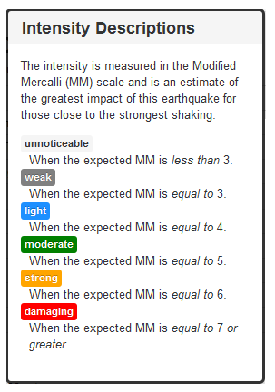
So you see, you will have to click the link to get all of the quake details and the final location. But you will be able to see, within a few minutes, that there was a event of xx intensity in xx area. (reminder on intensity at the bottom of the page)

From early September you will see these changes on Twitter, Facebook and emails as well as on the website.
Frequent users of GeoNet Rapid and those of you with our android /iPhone apps will be more familiar with this.

We do understand this will take a wee bit of getting used to, but you will be getting information faster than ever before!

Wednesday, August 8, 2012

GeoNet.org.nz - Change is coming!


Back in 2002 this is what the GeoNet website looked like!
(Not very exciting!)

And I'm sure everyone knows what it looks like now!

But with the arrival of our new, faster earthquake location system SeisComP3 We have been busy behind the scenes upgrading GeoNet the website, to make our information easier for you to see.

Some of you would have seen this with our GeoNet rapid beta website

From the September 1st this will no longer be a beta-testing page, it will be the official site of GeoNet earthquake information. With all of NZs earthquakes posted and within a few minutes of their occurrence!  You can easily view by region and 'all' quakes or just 'felt' quakes.

Now something different we have done is made GeoNet into 3 different websites, they are all joined by the black bar you see at the top of the GeoNet rapid page. There is a volcano, earthquake and information site 

So although 3 different sites, they are all linked and will be easily accessible for you all. 

Second we have the Volcano beta site:

Here are a couple of screen-shots  (its online so some of you may have have a look). You can see we have all of the volcanoes in NZ and you can easily see their current status (eg erupting or not!)  
You can then click on a particular volcano and get more information on their status and see pictures and videos from the volcano cameras.


Now the third website is where you will get all of your information, and data. 

So what we do at GeoNet:
* Earthquakes - how we locate them what causes them etc.
* Volcanoes - how we monitor them, historic eruptions etc. 
and not forgetting landslides and tusnami.

You will also have all the information on our networks and equipment we use and access to all of our data we collect that is available for you to use (for free!!)
And we will have pages with information all grouped together on the latest events such as the Canterbury earthquakes and the latest eruption(s) in NZ. We will also have all the latest news, volcano alert bulletins and GeoNet news publications. Another neat thing is the look - as you can see on the right, the news articles will look far more interesting than they do at the moment. 
Now don't worry if you don't' see your favorite things in these screenshots, more content is being added (these sites are still being modified) and our www address will stay the same. Another great thing about the new website is the ease of use for us, and we can add new information - change volcano alerts etc and get it out to you right away.


So its the same GeoNet just faster and better looking!!


Monday, August 6, 2012

White Island Eruption Video


This movie is made from photos taken from our cameras on White Island on Sunday Morning 5th Aug. Luckily the moon was out!

Friday, July 20, 2012

Out and about - Southland, and learning NZ Geography

Two of our team (Sam & Lara) are currently down in Southland fixing a few pieces of our equipment. So i got them to send me a few pics so we could follow their adventures.


The pic on the left is WHZ (Weather Hill Road) the site has had an impaired signal lately and they think the trees could be the culprit!


Leaving Manapouri for DCZ


 The next stop was via helicopter to the remote DCZ (Deep Cove) site, where the satellite modem was faulty and affecting the comms. So they swapped it out.


And some locals came to see what was going on ...


 Cheeky Kea


 And here is Sam working out the gear while they wait for the helicopter to take them to Wednesday peak. 


Another thing that earthquakes have done recently, is teach us  places in New Zealand that we haven't heard of before! The team were kind enough to stop and take a photo of the Tuatapere sign for me!


I first heard of the town Tuatapere back in 2009 after the Dusky Sound earthquake where the location came through as "100 km north-west of Tuatapere" and left a few of us wondering where on earth is that ( i remember texting Lara)!!  A few years down the track and a few more shakes off the South Island have made the town quite well known.


They drove through Nightcaps and Ohai to get there too.

Monday, July 2, 2012

Snow season - watch out for volcanoes!

Winter has come, the snow has fallen and people are heading up to Mt Ruapehu for some fun. Now while this is great, and so pretty (this pic is from our webcam this morning) its also important to remember underneath all of that white stuff is an active volcano!

Now I'm not wanting to put you off going up there - its just like all of the hazards in NZ - just do a little research and be prepared!


One of the major hazards on the mountain in an eruption is a lahar = a  "mudflow" - a mixture of 
volcanic ash, rocks and water.


The last eruption on Mt Ruapehu was in September 2007, during this eruption explosions spread ash, rocks and water across the summit area, producing lahars in two valleys including one in the Whakapapa ski field.  In March 2007 the dam at the crater lake failed and produced a really big lahar :


If a volcanic eruption does occur at on the mountain an audio siren and message will sound from a series of speakers located around the ski area, immediately move to higher ground and out of valleys. Stay in a safe zone until you receive further instructions from Ruapehu staff.


Mt Ruapehu, the Department of Conservation and GNS Science have all worked together to produce volcanic hazard maps of Ruapehu and Whakapapa and Turoa ski areas:


So check them out before you head up the mountain!


Mt Ruapehu 1996

GeoNet monitors Mt Ruapehu (along with other volcanoes in NZ) with 3 web cameras, 10 seismographs and 6 microphones to detect volcanic explosions, frequent water chemistry and airborne gas measurements, and 8 continuous GPS stations to detect ground deformation.

For more info on Mt Ruapehu click here and info on the other volcanoes we monitor here.  

Mt Ruapheu website

Thursday, June 7, 2012

The Popular Ones

After reading online today that Google had released its stats for the month of May i had a wee look at how 'popular' GeoNet was!

And we made it in the top 10 rising searches in NZ!  GeoNet came in 9th with 60% growth in searches - maths, All Blacks, American idol, the GC, Facebook and Diablo were all ahead of us (Maths, really??)

Using 'Google Trends' we can look into this further:

In the pic below you can see that searches for our new website GeoNet Rapid have increased by 250% which is great! 


 It also tells us other websites people have looked at after visiting GeoNet which is (kind of creepy) really interesting! If you look below you can see that people who visited geonet.org.nz also visited some websites which were related eg. CERA, the Christchurch City Council. But the more interesting sites were lotto and holiday houses - now whats that saying!


Twitter also gives lists of the most popular accounts GeoNet is number 41 in the top 100 followed in the Wellington region (it only gave Wellington or Auckland)

And on Facebook our page received 315 new likes in May.

So thanks to everyone, you make us feel special!

Wednesday, May 23, 2012

GeoNet Rapid - Why is it different?

GeoNet Rapid has been up and running for a few months now so i thought i would go over a few things, the first is:

Quake history:


SeisComP3 is fast as it locates the earthquakes automatically (no humans needed).  As soon as it has enough data it is able to post a first location on GeoNet rapid, if you look at the pic above you can see the first location was posted 42seconds after the actual earthquake. 

As more data arrives, from more distant stations, the system refines the location (up to 4 minutes in the pic above)  and finally finishes when the last data has arrived (10min on the pic). This delay is caused by the time it takes from the earthquake P wave to travel to the stations - eg if there was an earthquake at Stewart Island, it would take around seven minutes for the earthquake wave to travel and be picked up by our sensors at Cape Reinga (top of the North Island). The very last change comes later on when one of our duty seismologists looks at the event.

Status/ quality:

As the event changes you will notice both the 'status' and 'quality' change along with it.  The status lets you know if the solution has been located 'automatically' or 'reviewed' by a human   - see figure B in the pic below.  the Quality changes as more information comes into the system - with few stations the solution has 'caution', many stations has 'good' and finally 'best' when a human has reviewed it - see figure A in the pic below.


Descriptions found by hovering over the ? on the website.


We have also added a keyword / colour coding system to the earthquake intensity so you can easily tell if an earthquake was damaging or unnoticeable - see figure C in the pic above.


So why is it different to www.geonet.org.nz?


Yes the earthquake locations on GeoNet Rapid will be slightly different to those on www.geonet.org.nz The main reason for this is that SeisComP3 uses a three dimensional velocity model, whereas www.geonet.org.nz uses a one dimensional model.

The three dimensional data model uses a lot of data collected by the GeoNet project as well as many other research projects in NZ. By using this model we are really improving the way we located earthquakes.

 Next....


GeoNet Rapid will be in full production by late September 2012, and will bring with it a whole new look to the GeoNet website and information, some exciting things to come!


PS: The official GeoNet app for your smartphones can be downloaded here for  Android  and the iPhone/Pad app will be available next month! Is available now!