Wednesday, November 21, 2012

Volcanoes, Eruptions, Oh My!

Well the second half of 2012 has been all about the volcanoes! Tongariro and White Island in August then maybe Ruapehu, but no Tongariro again!

So firstly some important information on what to do during during an ash fall event and lava flows and general information for before/during/after an eruption from CDEM.

Where to find information on our website:

Current status of the volcanoes, drums and cameras here
News and Volcanic Alert Buletins here
More information and history on Tongariro here and our other volcanoes here

What do the alerts mean?


So what does this mean?

Unfortunately we don't know what will happen in the days to come. As far as eruptions go this was just a small one, only lasting five minutes. And there were no signs that Tongariro was going to erupt again today, volcanoes can be sneaky like that!

We do have lots of seismic sensors on and around the volcanoes and cameras watching the mountains as well as a great team of experts currently looking at all of the data coming in! So we will be closely monitoring the volcanoes and putting out bulletins as more information comes in.
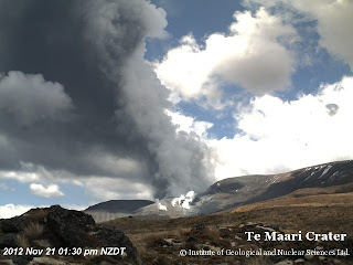
View from Te Maari Crater shortly after the eruption.


Friday, November 2, 2012

Lots of earthquakes - What does this mean?

Another comment we often see is "there have been xx earthquakes today, what does this mean"

We it means that we are living in a really interesting place! New Zealand is located on the boundary of two of the world’s major tectonic plates – the Pacific Plate and the Australian Plate. Below is a video explaining how this plate boundary creates earthquakes in NZ.


Another thing to remember with our new website is that we are showing you all of the earthquakes that we locate, the old website just had the larger/felt events.  And we locate over 20,000 earthquakes a year!

As you can see in the picture below, the earthquakes occur along the plate boundary in both the North and South Islands. The shallow earthquakes (under 40km deep) occur across quite a wide area (pink - red dots) while the deeper quakes (below 40km deep) occur on the sloping surface that shows where the plate boundary dips down at an angle (orange - yellow - blue dots)

All located earthquakes in 2011 (24,000) via QuakeSearch


Another cool thing you can see on our new website is a summary of earthquakes in the New Zealand region  here

You can see that as of this morning, we have had 168 earthquakes of mag 2-3 in the last week.


So lots of earthquakes in one area....

Can mean you are having a swarm = a swarm is a sequences of many earthquakes, usually in a short time period (hours to days). These occur all the time in NZ, with Taupo, Rotorua, Matata and Te Aroha being popular locations! 

They are normal processes and can be related to the long term tectonic stretching of the crust that occurs in the central North Island.


More info:

Stats on earthquakes from 1960

 
Neat Diagram of the plates in NZ

Video of the tectonic evolution of NZ

Historical Earthquakes in NZ